Thursday, 30 August 2007
Architecture professor uses virtual world to teach collaboration
Checkout this article: City Turns New Leaf in Second Life. It shows how Architecture Professors are using second life as a tool to teach students how collaboration can be achieved.


Architectural Visualisation from Neorama
Neorama is a Brazilian and an international provider of Architectural Visualisation solutions. There vision is one of 'a constant search for a sharp and accurate creative vision, allying art and technology to reinforce property features and values'. Below are animations created by Neorama:
They are now moving into second life architectural visualisation as represented by there recent completion of project on Dellano in second life which to me looks a bit like the farnsworth house.
Further info visit Digital Urban blog post.
They are now moving into second life architectural visualisation as represented by there recent completion of project on Dellano in second life which to me looks a bit like the farnsworth house.
Further info visit Digital Urban blog post.
Friday, 24 August 2007
Microsoft's new search interface called Tafiti

Mocrosoft has just released a new search engine interface called Tafiti. It users microsoft silverlight technology and live search to enable interactive searching. It also enables the viewer to save searched information such as images, rss feeds, etc. Below is a video showing Microsoft's Tafiti in action:
Thursday, 23 August 2007
Google Earth Launches Galaxies
A new version of Google Earth has been launched which includes galaxies. You get a 3D view of all the constellations viewable from earth, and you can explore them in 3D. 100 million stars and 200 million galaxies are included. Belowis a video showing the new features of GE v4.2:
Further info visit webware blog post on GE.
Further info visit webware blog post on GE.
Reflexive Architecture
Reflexive architecture is a new direction within the world of virtual architecture whereby the building elements are responsive to the presence of a person.Below is a video showing a gallery of reflexive architecture on Second Life explored by Keystone Bouchard.
Further info visit ARCH blog post on reflexive architecture. For further sources on reflexive architecture click here.
Further info visit ARCH blog post on reflexive architecture. For further sources on reflexive architecture click here.
Web 1.0 vs Web 2.0: A Visual Difference
For those who do not understand the difference between web 1.0and web 2.0 below is an image which shows a visual difference between the two rather than finding wordy definitions which do not make too much sense.

Further info visit sizlopedia blog post.

Further info visit sizlopedia blog post.
Hyposurface
Hyposurface is a new interactive 3 dimensional moving wall surface which is mainly used to display advertising. It uses a powerful 'information bus' technology to control many thousands of moving objects and allowing high speed movememnt in real time off the screen surface. Below are videos showing the new product in action:
Further info visit Hyposurface website and architecture.mnp blog post.
Further info visit Hyposurface website and architecture.mnp blog post.
Embedding Google Mymaps Directly
As my earlier post showed how to embedd Google Maps into your website or blog using other external websites or sources. Google Maps NOW has this feature directly available from today as represented by the image below which shows where it is located:

Further info visit Digital Urban blog post.

Further info visit Digital Urban blog post.
Sunday, 19 August 2007
Steven Holl's Linked Hybrid Project in Beijing
Steven Holl's Linked Hybrid project in Beijing is quite a good example of a sustainable design. The project consists of several buildings linked together to create a city within a city. Some of its sustanability features include green roof gardens, geo thermal wells to heat and cool the building and a recycled grey water pond.
Below is a presentation in two parts showing the architecture of the design and its green features.
Further info visit architecture.mnp blogspot which shows a great deal of green architecture features of the project.
Below is a presentation in two parts showing the architecture of the design and its green features.
Further info visit architecture.mnp blogspot which shows a great deal of green architecture features of the project.
Wednesday, 15 August 2007
Holographic Technology
Holographic Technology is a developing technology which displays a projection of an image in mid air. Heliodisplay is a product on the market developed by I02 Technology which displays video images and projects it into free-space or mid air. The video below shows an overview of the product developed.
For further info visit Digital Urban blogpost which shows the recent development of holographic technology in detail and how it can be used to produce digital cities and virtual world interactively.
For further info visit Digital Urban blogpost which shows the recent development of holographic technology in detail and how it can be used to produce digital cities and virtual world interactively.
Thursday, 9 August 2007
Dubai Waterfront
Dubai's waterfront is proposed to be the largest waterfront development in the world. The project includes many groups and organizations working collaboratively in order to develop the project by creating various management processes such as feasibility studies. Below is a promotional video showing Dubai Waterfront development and planning.
For further info visit Digital Urban blog post.
For further info visit Digital Urban blog post.
Wednesday, 8 August 2007
Understanding some powerful web 2.0 tools
Some of the web 2.0 tools such as social bookmarking and RSS feeds are difficult to understand. Below are two videos showing what social bookmarking is and what RSS is in plain english.
Fo further info and more videos on web 2.0 tools visit commoncraft or there YouTube videos
Fo further info and more videos on web 2.0 tools visit commoncraft or there YouTube videos
Tuesday, 7 August 2007
tutorials on YouTube
The power of web 2.0 is changing the way we learn. YouTube, one of the giants in the web 2.0 world has a lot of video tutorials for 3dsMAX and other software's such as sketchUp and photoshop. It is just easier to view tutorials interactively rather then using other sources such as text books. Books can be very painful to read and get useful information out of it whereas, with video tutorials it can easily be viewed and at the same time you could be using the software. The learning process is just simply easier with digital technology and it's FREE!!
Below is a tutorial on chapter 1 of a series of tutorials on 3ds Max hosted on YouTube by a user called prabinpebam.The user has more tutorials uploaded mainly on 3ds MA and a few on photoshop.
Further info visit Digital Urban blog post.
Below is a tutorial on chapter 1 of a series of tutorials on 3ds Max hosted on YouTube by a user called prabinpebam.The user has more tutorials uploaded mainly on 3ds MA and a few on photoshop.
Further info visit Digital Urban blog post.
Architectural Animation - 3D Blue Print
3D Blue Print is another company which producers 3D visualisation and animations for architects, designers and developers. Architectural animations are currently developed by using the 'flying in' construction animation method which is quite impressive but is over used.
3D Blue Print starts off with an interesting play on the concept of scale with a building emerging from a tabletop site plan shown in the animation below:
Visit previous blog post of squint/opera to checkout there architectural animations.
3D Blue Print starts off with an interesting play on the concept of scale with a building emerging from a tabletop site plan shown in the animation below:
Visit previous blog post of squint/opera to checkout there architectural animations.
Monday, 6 August 2007
Google Maps Image Cutter
Image Cutter is an application developed by CASA which takes any image and cuts it into tiles which then can be viewed interactively via a Google Map. Using this tool, the viewer is able to zoom and pan using the standard Google Map interface. This is a very useful tool to publish images on the web.
Below is an example using the Google Maps Image Cutter tool.
You can download Image Cutter for free which users java application to run the software and creates a html file and a directory folder of the tiled images which then can be uploaded to your server. For further info visit Digital Urban blog post.
Below is an example using the Google Maps Image Cutter tool.
You can download Image Cutter for free which users java application to run the software and creates a html file and a directory folder of the tiled images which then can be uploaded to your server. For further info visit Digital Urban blog post.
Thursday, 2 August 2007
Online Storage: File Hosting and Sharing Sites
If you are wanting to store, backup or share your files online then this particular blog post on Mashable has put together 80 different websites which allows online backup, sending services, storage/sending services and many more file hosting tools. File hosting and sharing is quite useful because you can only attach smaller files via e-mail to share whereas, bigger files can be stored and shared online via file hosting websites.
I particularly like Mediafire because you don't have to register or login and once a file is uploaded, it provides you with a link which you can then share. It lets you upload up to 10 files of up to 100MB each at a time and has unlimited storage.
I particularly like Mediafire because you don't have to register or login and once a file is uploaded, it provides you with a link which you can then share. It lets you upload up to 10 files of up to 100MB each at a time and has unlimited storage.
Uploading Videos to YouTUBE with max quality
YouTubeis one of the busiest video sharing site. As a result, some of the videos tend to be better than others as far as quality is concerned. Below are two links to websites which show how you can optimize your videos for YouTube so the quality is not totally lost. The websites provide a guide and show the various features YouTube users to upload your videos.
blog post from CrunchGear and post on this website.
blog post from CrunchGear and post on this website.
Wednesday, 1 August 2007
Understanding Wiki
Wiki is like a collaborative website which can be directly edited by anyone with acess to it. It is simply an online database that could be used in communicating via a website which enables people to edit a page by using a simple markup language using a web browser. The most common of all being wikipedia - the free online encyclopedia. This is a great tool for working collaboratively where group or team members can write and edit stuff somultaniously. However, biggest disadvantage mainly with open-source wiki systems such as wikipedia it is easy for anyone to change information which could either be true or false.
There are a few websites which enable people to create there own wiki's such as : Wetpaint, pbwiki or wikispaces
Below is a video explaining what Wiki is and how it can be used in collaborative work.
There are a few websites which enable people to create there own wiki's such as : Wetpaint, pbwiki or wikispaces
Below is a video explaining what Wiki is and how it can be used in collaborative work.
How to embed a Google Map on your website or blog
There are quite a few websites which show you how to embed a Google Map on your website or blog. One of them is My Maps Plus. My Maps Plus is a site that lets you embed maps created using Google My Maps into any blog or website. Google My Maps feature allows you to create mashups which then can be embedded into your website or your blog (click here to view my previous blogpost on Google My Maps) . Another useful website is map-generator.net which allows you to generate your own map and embed it to your homepage. Other cool services include Frappr which is a web based community mapper another web 2.0 service developed after Google released the API for the Google Maps service.
Below is a map I created using Google My Maps and using My Maps Plus to embed it.
Further inf visit here or check previous blogs for Google maps and Google mapplets.
Below is a map I created using Google My Maps and using My Maps Plus to embed it.
Further inf visit here or check previous blogs for Google maps and Google mapplets.
Monday, 30 July 2007
A Closer Look at Microsoft's Virtual Earth
Microsoft's Virtual Earth is the competitor of Google Earth. Not much has been said about Virtual Earth. It simply comprises of similar features to that of Google Earth in terms of navigation however, Google Earth is just too ahead of Virtual Earth in terms of usage and its various features such as importing sketchup models and creating your own mashups. New features are still getting developed for Google Earth users. I guess one of the cool feature of Virtual Earth is navigating via a browser which shows 3D buildings as well and the quality of the resolution of the 3D buildings is much better than Google Earth.However, a plugin needs to be downloaded which can take several minutes.
Below is a video showing Stephen Lawler of Microsoft giving a talk on Virtual Earth.
Below is a video showing Virtual Earth in action:
More info visit: Inside Microsoft blog post.
Below is a video showing Stephen Lawler of Microsoft giving a talk on Virtual Earth.
Below is a video showing Virtual Earth in action:
More info visit: Inside Microsoft blog post.
Second Life and Architectural Practice
Some architectural firms are starting to use Second Life as a professional tool for architectural collaboration, presentation and communication with clients. With SL it is easier to communicate designs to clients as they are able to walk into the built design concepts and have meetings sitting inside the designs instead of describing drawing over the phone. The more virtual models enable clients to interact with them and make changes to them.
Autodesk have already started an island on SL and softwares which import AutoCAD models into SL have already been developed. One particular software "Henshin" will be available soon. Below is a demonstration video showing how to import AutoCAD models into SL using Henshin.
For further info: visit The ARCH blog post on Second Life and Architectural Practice and New World Notes blog post on AutoCAD into SL
Autodesk have already started an island on SL and softwares which import AutoCAD models into SL have already been developed. One particular software "Henshin" will be available soon. Below is a demonstration video showing how to import AutoCAD models into SL using Henshin.
For further info: visit The ARCH blog post on Second Life and Architectural Practice and New World Notes blog post on AutoCAD into SL
Saturday, 28 July 2007
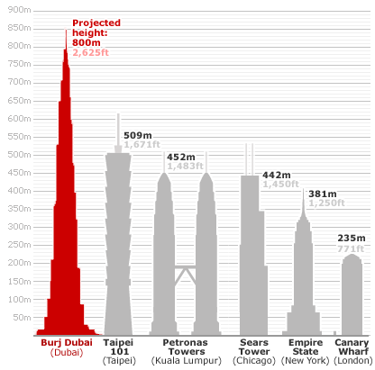
Burj Dubai: The Tallest Building


Burj Dubai currently under construction will be the tallest building and the tallest man-made structure in the world. In fact as at of 21 July 2007, the tower's developers reported Burj Dubai's height as 512.1m with 141 completed floors surpassing Taipei 101 (509.2m) as the tallest high rise building in the world.
Burj Dubai designed by Skidmore Owings and Merill will comprise of 162 floors and an overall height of aprox 808m.
The SketchUp Show
Google SketchUp is a free modelling tool which has a lot of features such as importing models into Google Earth. A new podcasting website called The Sketchup Show has been created to help people use SketchUp. It includes video podcasts on tips, tricks and tutorials on modelling in SketchUp. A SketchUp blog has also been created which includes tutorials and other useful information.
Photoshop CS3's photomerge feature

Photoshop CS3 has a feature which creates panoramic views. The new photomerge feature combines several photographs into one continuous image. It automatically stitches them together to create panoramic views. You can also create interactive panoramic views.
I think this feature is available in CS2 and CS to some extent.
To view a video tutorial on how to use the photomerge feature on CS3 click here.
Tuesday, 17 July 2007
MyVu Personal Media Viewer

MyVu Corporation a company, has developed a product to view ipod videos through a new dimension. It has developed glasses which project videos which can be viewed via a virtual big screen. An amazing technology however, it has some issues which needs to be developed further. It can be purchased via the product website.
For further info visit the blog post on EcoGeek which shows the sustainability of the design and its 'green' features.
Subscribe to:
Posts (Atom)