Showing posts with label google_earth. Show all posts

Tuesday, 2 February 2010

Take a virtual tour of the Winter Olympics in 3D

The countdown to the 2010 Winter Olympics has begun, and the Google Boulder office has been busy modeling the Olympic venues in Vancouver, BC using Google SketchUp.


Last month, we introduced photo-realistic 3D models for eight of the nine venues hosting the games.

Today, we released updates to many of the models using higher-resolution imagery, and, the last venue for the Olympics: the Bobsled Course!

Olympic venues (click to enlarge)


With today's release, all nine venues (54 buildings in total) are completely modeled in 3D and available for viewing in Google Earth's "3D Buildings" layer (or view the collection in the Google 3D Warehouse). The collection includes 3D models that range from downtown event centers to ski lifts and spectator bleachers.

In addition, the Vancouver Organizing Committee for the 2010 Olympic and Paralympic Winter Games incorporated the models into the Official website using the Google Earth plugin. To see the models, simply click on "Spectator Guide," then "Venues." You'll find a "3D View" tab that loads the 3D model.

So wax your virtual skis and take a tour!

Via Google

Wednesday, 11 November 2009

Epic Announces Free Unreal Development Kit Epic Games, Inc. has announced the launch of the Unreal Development Kit (UDK), a fre

Epic Games, Inc. has announced the launch of the Unreal Development Kit (UDK), a free edition of Unreal Engine 3 that provides community access to the game engine and toolset.

The software release is available to anyone interested in using 3D game engine technology, including game developers, students, hobbyists, researchers, creators of 3D visualizations and simulations, and digital filmmakers:


There is no charge for noncommercial or educational use of UDK. Over 100 academic campuses currently use Unreal Technology as part of teaching game development-related courses.

Anyone can start working with the industry-leading Unreal Engine 3 toolset by downloading UDK at www.udk.com, where detailed product features, technical documentation, commercial licensing terms, support resources and more are also available. This is quite an interesting development as it could enable some neat architectural ports into the engine.

Wednesday, 14 October 2009

Introducing Google Building Maker

Hot on the heels of the SketchUp 7.1 launch a couple of weeks ago, we're pleased to announce the release of the latest addition to our 3D family: Google Building Maker is a super-specialized, online tool for creating buildings specifically for Google Earth.

Building Maker lets you choose a building to model by looking at aerial imagery. After you've told it what you'd like to model, Building Maker loads up several different aerial views of that building taken from different directions. You then align simple 3D shapes – boxes, prisms, pyramids and others – to the different views. Building Maker takes care of all the photo-texturing for you; it uses the aerial photos to "paint" your building when you save it. Models you create with Building Maker are stored in the Google 3D Warehouse, and are automatically considered for inclusion on the 3D Buildings layer in Google Earth. If your model looks good (and if there's no better one already in its place), it'll appear in Google Earth (for millions of people) within about a week.

Check out this video to see Building Maker in action:


We're launching with 50 cities that are ready for Building Maker. We'll continue to add cities as fast as we can, but feel free to jump in and give Building Maker a test drive whenever you like. Modeling in a place you're not familiar with is a great way to learn something about it.

So is Building Maker supposed to replace SketchUp? Absolutely not! SketchUp is a general-purpose tool that people use to model everything under the sun. Building Maker, on the other hand, is a specialist. For folks who want to make models and see them in Google Earth, it's simple, efficient and (we hope) downright fun.

Here's something else we think is neat: Anything you create with Building Maker, you can download and open in SketchUp. You can tweak textures, refine geometry – whatever it takes to make your building even better. When you're done, uploading your improved model to the 3D Warehouse further increases its chances of being accepted into Google Earth.

Some more things you should know about Building Maker:
  • Building Maker is an online app, meaning it runs entirely in your web browser (Google Chrome, Firefox, Safari, Internet Explorer, etc.).
  • To get credit for what you contribute, you need to sign into your Google Account.
  • Make sure you have the latest version of Google Earth installed on your computer.
  • If you're on a Mac, you need to download the Google Earth plug-in directly.
Building Maker is free and available in 14 languages. Go to www.google.com/buildingmaker to join the worldwide mapping community. Have fun!

Via Google


Thursday, 24 September 2009

All about LayOut 2.1

Now that SketchUp 7.1 is out the door, I thought it'd be a good idea to tell you a little bit more about its 2D, Pro counterpart: LayOut 2.1 is more powerful than ever. We added features that should let you use SketchUp Pro for an even larger chunk of your workflow:


Dimensions!
LayOut isn't just for presentation documents anymore. LayOut 2.1 gives you the ability to add precise dimensions to your work. Use the new Dimension tool on any inserted SketchUp model to produce a set of dimensioned drawings quickly and easily. But enough tooting our own horn; here's what some of our esteemed beta testers have been saying over the last few weeks:

"To all the Googies! Dimensioning in LO is the best thing since sliced bread and eating half a loaf a day this is SO welcomed! Getting fat though!" – Richard Jeffrey
"Thank you, thank you, thank you for the dimensioning tool in Layout. We’ve been praying for this for a long time. I can’t adequately express how much it means to my work process." – rdwilkins
"When Google introduce Layout, I asking myself what to do with it. Then I use Layout for a building permission and get congratulation from the mayor of the city. Then, I burn the license of the bad 2D CAD program I use with SketchUp." – Christophe Hébert
"I have just attempted my first set of construction dwgs with LO. Although a simple project it was good to see how the new dimension tool in LO would help." – Andrew Carter
"...Dims in LO is fantastic. I am now taking LayOut VERY seriously as a Con Doc Production app rather than just a presentation app as I had been doing until now." – "Mayor" Mike Lucey

"AutoCAD and I just broke up!" – Eric Schimelpfenig

You can watch a short video I made about Dimensions in LayOut 2.1, then check out this how-to video from Tyson:


Snap to SketchUp Model
Elements like lines, labels and dimensions automatically snap to points in the SketchUp models you insert in LayOut 2.1. When Object Snap (Arrange > Object Snap) is enabled, colored point inferences appear as you hover over edges, endpoints and faces in inserted SketchUp model views. Elements you create while snapped to points in a model are sticky; they remain attached when the underlying model view is moved around on your page. Naturally, this applies to dimensions, but it also works with labels and shapes (like door swings).

Improved Freehand tool
We tweaked the Freehand tool to make it even easier to draw smooth, perfect vector lines with a mouse. As you draw, LayOut figures out where to put the control points so that your shape stays recognizable but editable. Now you can draw things like scale figures, free-form graphics and foliage right inside LayOut.

Bulleted and Numbered Lists
LayOut 2 makes it easy to include lists – bulleted or numbered – in your text. Before, only Mac users could do this. Now, everyone can.

Improved Grids
In LayOut 2.1, you can choose to display your grid as dots instead of lines; sometimes this makes it easier to see what you're doing. You can also tell LayOut to draw your grid (dots or lines) in front of your drawing elements. After all – what good is a grid if you can't see it?

Improved Copy/Paste
We've made it easier to move elements like graphics and text between LayOut 2 and the other programs in your design toolbox.

Tweaks and other goodness
Needless to say, we didn't just add a bunch of new features in 2.1. Our crack team of amiable nerd-types have been squashing bugs and fiddling with code for months. And as always, many thanks go out to the selfless beta testers who've helped make LayOut better with every release.

Via Google

Wednesday, 23 September 2009

Google SketchUp 7.1 now available

Site Plan dimensioned in LayOut 2.1

Site Plan dimensioned in LayOut 2.1


Dimensions for 3D Models embedded in LayOut 2.1

Dimensions for 3D Models embedded in LayOut 2.1


(those are not my designs)


As for collaboration, the new features are both in export/import and
online capabilities. For example, you can now Import and Export in the COLLADA
(COLLAborative Design Activity) format, a 3D file format based on open
standards that allows you to easily work exchange information across
different 3D softwares (Maya, Poser, 3DS Max, LightWave, Cinema 4D,
Softimage XSI, Houdini, Blender, Modo, Strata 3D  and more). With
SketchUp Pro 7, you can import and export files in a number of 2D and
3D formats, including DXF, DWG, 3DS, OBJ, XSI, EPS, PDF and more.


Upload component context menu shown for one building among many being modeled

Upload component context menu shown for one building among many being modeled


You can now upload components straight from SketchUp to Google’s 3D
Warehouse. Previously, you needed to put the component isolated on a
new file to upload it. For example, you can now split large city models
into buildings, preserve Dynamic Component functionality and more.


Nearby By model search in SketchUp 7.1 Component Browser

Nearby By model search in SketchUp 7.1 Component Browser


And this urban approach gets more and more exciting, as it is now
possible to import and export the now popular KMZ format, extending
geo-location usage. You can even browse nearby models from inside
SketchUp.


Photo Texture window in SketchUp 7.1 on a Mac

Photo Texture window in SketchUp 7.1 on a Mac


And probably one of the most exciting features is the integration
with Google Streeview, which allows you to take textures directly from
actual views of the city (where available). Imagine how fast and
accurate you can model a city or your project’s context with this
tools. And if you add collaboration with your teamwork (or other users)
with components and nearby models… it becomes a powerful tool.


For more information, download a SU Pro trial version or the Free edition, just go to the Google SketchUp website.

Via Arch Daily


Saturday, 19 September 2009

Dynamic 3D Models in Google Earth: Traffic and Pedestrian Visualisation


The movie clip below provides an insight into some particularly note worthy research, not just in terms of Google Earth, but also in terms of collecting and visualising traffic and pedestrian data:


Its not the overlaying of video clips in Google Earth, but the animation of complex traffic patterns in a digital city which we see as innovative. This has notable potential for populating city models with real-time traffic and crowd data as well as for the validation of agent based models.

Picked up via http://www.gearthblog.com

See http://www.cc.gatech.edu/cpl/projects/augearth/ for full details - very neat.

Via Digital Urban


Monday, 31 August 2009

Google Earth and Google Maps updates Wellington Maps

A couple of cool new features have arrived at Google Maps.

First, the images used in the satellite tiles have been updated, and with images of a higher resolution so you can zoom in right down to the smallest click on the slidey thing.

The old images pre-dated the bypass, so it's good to see more up-to-date images.

Also, the images appear to have been taken on a bright sunny day and the city looks absolutely gorgeous.

Wellington is the first city in Australasia to have Google Transit, as reported in this envious article in the Herald.

Alan's already had a bit of a play with it:


And we've had a look and it seems pretty useful - much easier to use than the famously crap Metlink website.

There's still a few things that need to be tidied up (it seems to think that the Airport Bus drives across the harbour), and it would be great to be able to specify which type of public transport you want to search for. But we're mostly enthused by this new addition.

Via wellingtonista


New SketchUp Coming Soon

The Official SketchUp Blog posted last evening hinting at a possible new version coming soon.

Some major news in the article is that the dxf/dwg importers will be removed from the Free version of SketchUp. (The Pro version will still have them.)

In the next release of Google SketchUp, our free modeler, we've decided to remove the dwg/dxf importers. We know how important these importers are to our professional customers, especially those who depend on CAD products in their daily work. And for that reason we'll focus our attention on supporting them in Google SketchUp Pro, where we really understand all the nuances of your workflow and where we can provide professional support to troubleshoot your issues.


It seems like this is going to hit a lot of people pretty hard. The license for the Free version allows commercial use, and I would guess a lot of small businesses and individuals who otherwise could not afford it are using the Free version for business. No longer having the ability to import drawing files could really hurt.

Read it here.

Via sketchup plugins

Thursday, 27 August 2009

Feed me 3D

Google added a feature to the Google 3D Warehouse that allows you to track search results and collection contents using a feed reader, like Google Reader. How is this useful? Well, suppose you wanted to keep an eye on which buildings in your town were being accepted into Google Earth.


Here's how it works:
  1. Go to the Google 3D Warehouse and type in your search; in our example "near:[city] is:best-of-geo".
  2. Click the "Sort by date" link under the top blue bar.
  3. Click the "Subscribe to this search" link in top right corner. This allows you to subscribe to the search results using a feed reader.
  4. Choose your favorite feed reader to subscribe to the feed.
  5. If you're starting in SketchUp you'll need to right click on the link, select "Copy shortcut" (PC) or "Copy Link" (Mac), and past the results into your reader. Browsers may use different terminology in the right-click menu; Chrome uses "Copy link address" and Firefox uses "Copy Link Location".


When you open Google Reader, you can see the latest entries:


Via Google

Thursday, 6 August 2009

Population Density: Google Maps Census System Preview

At the moment here at CASA we are working on a phase one deliverable of a new grant entitled NeISS - National e-Infrastructure for Social Simulation. Funded by the JISC as part of its Information Environment Programme it will provide a platform to meet the demand for powerful simulation tools by social scientists, public and private sector policymakers. Social Simulation is an expanding field due to its forecasting applications for scenarios in transport, housing, education, healthcare etc.

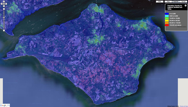
Our first of many outputs is to visualize the UK Census data via MapTube and we thought we would share some of our first results as they make for quite intriguing images - such as the screen grab below detailing Population Density of the Isle of Wight:


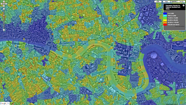
The work is ongoing with the ability to 'click' on areas and view the underlying data as well as data streaming and varying levels of detail all forthcoming. Countywide, zoomable down to local level Cenus data is hard to come across, for a quick view is provides quite a good way to identify pattens in the urban landscape. Below is Central London:


Our back end system under development means that the output is not limited to the UK Census, it would be interesting to make this a global tool, more on this in future posts...

You can see sample map of Population Density direct via MapTube.

Via Digital Urban

Tuesday, 21 July 2009

SketchUp goes to the Moon!

With the launch of Moon in Google Earth today, you can now explore our nearest celestial neighbor from within Google Earth. Beginning in 1959, we began to send probes and landers to the lunar surface, and most of them remain there to this day.


Many of these objects have been modeled in Google SketchUp, and are based on drawings, photographs, and dimensions. One model that has a prolific presence on the Moon comes from Google 3D Warehouse model contributor, Pagan. This user modeled the Apollo Lunar Module and it is featured at each of the Apollo mission landing sites, as well as in the guided tours.

To view these models in Google Earth, first switch to Moon via the planetary drop-down menu at the top of the screen.


Next, expand the "Moon Gallery" in the left Layers panel.

From here you can virtually visit a variety of artifacts, spacecrafts, and mission landing sites by double-clicking on any of the models listed. Here are some examples of what you can find:


Apollo 11 Landing Site


Lunokhod 1 and Luna 17

Lunar Rover

You can also view these models in SketchUp by downloading them from our Moon Objects collection in the Google 3D Warehouse. Happy exploring!

Via Google

Wednesday, 8 July 2009

PhotoSketch Launched with 30 Day Trial


PhotoSketch by Brainstorm Technology LLC is now available with a fully functional 30 day trial version available for download. PhotoSketch is a Google SketchUp plugin that enables the user to model 3D urban structures directly from photographs. It is aimed at architects, designers, and entertainment content creators allowing a new approach to create lightweight 3D models of existing buildings.


Sure you can model direct onto photographs already in SketchUp and indeed that is the basis of a lot of the models currently seen in Google Earth. Where Photoshetch seems to differ is the ability to determine camera positions and extract and match geometric features derived from a collection of overlapping photos of an urban scene.

Head over to http://www.brainstormllc.com/ for the download.

Via DigitalUrban

Thursday, 18 June 2009

See the steps to model for Google Earth

If you've wondered what the process really looks like for getting a 3D model into Google Earth, you should check out this new video (also included below). You'll see a building created from scratch in SketchUp, pushed up for review, and placed in Google Earth for all to see. It's soup to nuts. The building is very simple and the reference photos are great for modeling (if I do say so myself).

This video provides step-by-step directions describing how to use photographs, Google SketchUp, Google Earth, and the Google 3D Warehouse to create and upload a model for consideration in Google Earth's 3D Building layer. Check it out when you have a chance.


Thursday, 28 May 2009

Drag and drop your models with Creator

Esperient Creator is an interactive 3D application-authoring tool, that provides a WYSIWYG approach to creating interactive 3D applications. It's compatible with Google SketchUp and integrates right into your workflow. John D'Amours, President and Founder of Visual Training Solutions, uses Google SketchUp and the Google 3D Warehouse to create or find content. He then brings that content "to life" with Esperient Creator. He says, “SketchUp provides some great home furnishings, accents, and even unique materials and textures that can easily be modified and brought to life in RH and Esperient Creator. This is extremely useful for creating 3D instructions for improvement projects around the house, employees, and even marketing and communication tools. You never know what you’ll find in the Google 3D Warehouse…I always check there first.”

Check out this video that highlights a number of workflows using Google SketchUp and Google 3D Warehouse with Esperient Creator.


Saturday, 25 April 2009

SketchUp Scenes in Google Earth

Scenes in SketchUp can be used for many things, but they're most commonly used to save camera views and in creating animations.

SketchUp scenes also appear in Google Earth. The video below demonstrates this:


Via 3Dvinci


Wednesday, 22 April 2009

Urban Design for Google Earth

How do you create an identifying landmark for a city that is chiefly known as a place to pass through? This spring Pentagram Architects was invited by the City of Newark, New Jersey Division of Planning & Community Development to submit a proposal for “This Is Newark,” an initiative to create a series of “gateways” for the city.


Pentagram Architects used Google Earth to create these 'gateways' to address both remote and local audiences with a set of ideas that are legible in reality and cyber-reality. "In our concept, a series of painted “events” on the Newark streetscape would bring Newark to the world, and bring the world to Newark."


Read More about this project on Pentagram Blog.

Tuesday, 3 February 2009

Dive into the new Google Earth

Google Earth 5.0 is out and is available.

new features include:
* Historical Imagery: Until today, Google Earth displayed only one image of a given place at a given time. With this new feature, you can now move back and forth in time to reveal imagery from years and even decades past, revealing changes over time. Try flying south of San Francisco in Google Earth and turning on the new time slider (click the "clock" icon in the toolbar) to witness the transformation of Silicon Valley from a farming community to the tech capital of the world over the past 50 years or so.
* Touring: One of the key challenges we have faced in developing Google Earth has been making it easier for people to tell stories. People have created wonderful layers to share with the world, but they have often asked for a way to guide others through them. The Touring feature makes it simple to create an easily sharable, narrated, fly-through tour just by clicking the record button and navigating through your tour destinations.
* 3D Mars: This is the latest stop in our virtual tour of the galaxies, made possible by a collaboration with NASA. By selecting "Mars" from the toolbar in Google Earth, you can access a 3D map of the Red Planet featuring the latest high-resolution imagery, 3D terrain, and annotations showing landing sites and lots of other interesting features.

Read More

Video Showing the new features in action:

Thursday, 17 April 2008

The new Google Earth has landed


The new Google Earth 4.3 (beta) for Windows and Mac has arrived with new features, including some ported over from other Google products.

New features

- One of the more exciting additions to Google Earth 4.3 is the capability to switch on day and night views.

- News that Street View, which you may remember from Google Maps, will be woven into the version update, complete with the familiar photo viewer.

- Speed is someting which is improved on. 3D buildings will render faster and Google Earth 4.3 accelerates the switch between Earth and Sky modes.

- Images will be getting time stamps for easily seeing when they were created. Since so many photo sources populate Google Earth, not every image will bear a born-on date, but those that do will add another layer of information.

- Finally, Google is updating the look of the application's navigational controls to make mouse and keyboard scrolling easier.

Making models with Google SketchUp is a good way to populate Google Earth, or to create your personal version of it. If you prefer to create your own 3D landscapes, Bryce is the freeware application to use. DAZ Studio, is another software that offers the same extensive range of modeling freedom.

Via Mashable and Webware