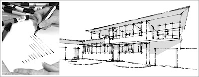
There's a new plug in for SketchUp which allows you to create your own sketchy-edge Style that you can use to make your SketchUp models look hand-drawn. The plug-in is called Style Builder (Beta) and is for SketchUp pro 6.
Below is a video showing the STyle Builder in action:
Microsoft has released a Beta version of a plugin to let Photoshop read and write files in the HD photo fomat.
The plug-in is available for free to download for Windows and Mac OS X systems. The plug-in works on Windows XP, Vista, Mac OS X 10.4 and 10.5 and Photoshop CS2 and CS3.
Google Earth has added a new feature which lets users know what the weather is like while they zoom around the 3D application. It has a new layer that lets users toggle cloud cover, Doppler radar, and conditions and forecasts.
The Toilet-Shaped house is in fact named Haewoojae, which signifies in Korean "a place of sanctuary where one can solve one’s worries". The Toilet-Shaped House has a very unique design, and was built by Sim Jae-duck, the chairman of the organizing committee of the Inaugural General Assembly of the World Toilet Association, and he hopes his toilet house will highlight the global need for better sanitation.
We all need to organize our thoughts sometimes, and there seems to be no better way to do it than in a visual fashion. Mashable has got a list of 30+ mind mapping tools to help you do just that. And since some of you are on a budget, they've listed free and paid suggestions for you.
Stanford University research project on converting bitmap images to vector art, aka "auto tracing" or "automatic vectorization". Similar to Adobe Illustrator's Live Trace and CorelDRAW's PowerTRACE but works better in many cases. Upload image and get a converted result (EPS/SVG) in a few moments.
The Digital House is the culmination of two-and-a-half years of research and development by the architects Bell Travers Willson, made possible by funding from the London Development Agency, with the aim of enhancing traditional house building through the use of digital technology.
In this tutorial we are going to show you how to easily create digital abstract smoke using Illustrator and Photoshop. One of the best things about this technique is that it’s very customizable and you can do it pretty quickly.
Another tutorial of creating a smoke effect can be found here.
Greenspace Research have developed an extension on a building energy analysis tool for SketchUp which is currently at its Beta stage.
The tool expands the benefits of using SketchUp for early conceptual design integrating the power of Green Building Studio's energy report system.
The system is based around the Green Building XML schema, referred to as “gbXML”, developed to facilitate the transfer of building information stored in CAD building information models.
Below is a video showing an insight of the plugin being used:
Below is a video showing a demonstration on the new online based photoshop called photoshop express which will be launched soon. This particular application will fully be a flash-based image editior and will run inside a web browser.
The application focusses at consumers rather than proffesional developers however; it would be a faster and a much efficient way in editing images online especially when you using internet cafes while traveling. Im just not sure about the speed due to the application being all flash-based.
Google Earth has a flight simulator feature which can be used by holding Ctrl-Alt-A tobring up the flight simulator and after that, Ctrl-A or a selection from the tools menu activates it. I found the simulator quite slow but interesting to navigate in 3D.
Space Navigator is a new product by 3Dconnexion which allows you to navigate easily through 3D appications such as Google Earth. It makes it easier to zoom, pan and rotate when viewing 3D imagery as shown below:
Checkout this article: City Turns New Leaf in Second Life. It shows how Architecture Professors are using second life as a tool to teach students how collaboration can be achieved.
Neorama is a Brazilian and an international provider of Architectural Visualisation solutions. There vision is one of 'a constant search for a sharp and accurate creative vision, allying art and technology to reinforce property features and values'. Below are animations created by Neorama:
They are now moving into second life architectural visualisation as represented by there recent completion of project on Dellano in second life which to me looks a bit like the farnsworth house.
Mocrosoft has just released a new search engine interface called Tafiti. It users microsoft silverlight technology and live search to enable interactive searching. It also enables the viewer to save searched information such as images, rss feeds, etc. Below is a video showing Microsoft's Tafiti in action:
A new version of Google Earth has been launched which includes galaxies. You get a 3D view of all the constellations viewable from earth, and you can explore them in 3D. 100 million stars and 200 million galaxies are included. Belowis a video showing the new features of GE v4.2:
Reflexive architecture is a new direction within the world of virtual architecture whereby the building elements are responsive to the presence of a person.Below is a video showing a gallery of reflexive architecture on Second Life explored by Keystone Bouchard.
Further info visit ARCH blog post on reflexive architecture. For further sources on reflexive architecture click here.
For those who do not understand the difference between web 1.0and web 2.0 below is an image which shows a visual difference between the two rather than finding wordy definitions which do not make too much sense.
Hyposurface is a new interactive 3 dimensional moving wall surface which is mainly used to display advertising. It uses a powerful 'information bus' technology to control many thousands of moving objects and allowing high speed movememnt in real time off the screen surface. Below are videos showing the new product in action:
As my earlier post showed how to embedd Google Maps into your website or blog using other external websites or sources. Google Maps NOW has this feature directly available from today as represented by the image below which shows where it is located:
Steven Holl's Linked Hybrid project in Beijing is quite a good example of a sustainable design. The project consists of several buildings linked together to create a city within a city. Some of its sustanability features include green roof gardens, geo thermal wells to heat and cool the building and a recycled grey water pond.
Below is a presentation in two parts showing the architecture of the design and its green features.
Further info visit architecture.mnp blogspot which shows a great deal of green architecture features of the project.
Holographic Technology is a developing technology which displays a projection of an image in mid air. Heliodisplay is a product on the market developed by I02 Technology which displays video images and projects it into free-space or mid air. The video below shows an overview of the product developed.
For further info visit Digital Urban blogpost which shows the recent development of holographic technology in detail and how it can be used to produce digital cities and virtual world interactively.
Dubai's waterfront is proposed to be the largest waterfront development in the world. The project includes many groups and organizations working collaboratively in order to develop the project by creating various management processes such as feasibility studies. Below is a promotional video showing Dubai Waterfront development and planning.
Some of the web 2.0 tools such as social bookmarking and RSS feeds are difficult to understand. Below are two videos showing what social bookmarking is and what RSS is in plain english.
Fo further info and more videos on web 2.0 tools visit commoncraft or there YouTube videos
The power of web 2.0 is changing the way we learn. YouTube, one of the giants in the web 2.0 world has a lot of video tutorials for 3dsMAX and other software's such as sketchUp and photoshop. It is just easier to view tutorials interactively rather then using other sources such as text books. Books can be very painful to read and get useful information out of it whereas, with video tutorials it can easily be viewed and at the same time you could be using the software. The learning process is just simply easier with digital technology and it's FREE!!
Below is a tutorial on chapter 1 of a series of tutorials on 3ds Max hosted on YouTube by a user called prabinpebam.The user has more tutorials uploaded mainly on 3ds MA and a few on photoshop.
3D Blue Print is another company which producers 3D visualisation and animations for architects, designers and developers. Architectural animations are currently developed by using the 'flying in' construction animation method which is quite impressive but is over used.
3D Blue Print starts off with an interesting play on the concept of scale with a building emerging from a tabletop site plan shown in the animation below:
Visit previous blog post of squint/opera to checkout there architectural animations.
Image Cutter is an application developed by CASA which takes any image and cuts it into tiles which then can be viewed interactively via a Google Map. Using this tool, the viewer is able to zoom and pan using the standard Google Map interface. This is a very useful tool to publish images on the web.
You can download Image Cutter for free which users java application to run the software and creates a html file and a directory folder of the tiled images which then can be uploaded to your server. For further info visit Digital Urban blog post.
If you are wanting to store, backup or share your files online then this particular blog post on Mashable has put together 80 different websites which allows online backup, sending services, storage/sending services and many more file hosting tools. File hosting and sharing is quite useful because you can only attach smaller files via e-mail to share whereas, bigger files can be stored and shared online via file hosting websites.
I particularly like Mediafire because you don't have to register or login and once a file is uploaded, it provides you with a link which you can then share. It lets you upload up to 10 files of up to 100MB each at a time and has unlimited storage.
YouTubeis one of the busiest video sharing site. As a result, some of the videos tend to be better than others as far as quality is concerned. Below are two links to websites which show how you can optimize your videos for YouTube so the quality is not totally lost. The websites provide a guide and show the various features YouTube users to upload your videos.
Wiki is like a collaborative website which can be directly edited by anyone with acess to it. It is simply an online database that could be used in communicating via a website which enables people to edit a page by using a simple markup language using a web browser. The most common of all being wikipedia - the free online encyclopedia. This is a great tool for working collaboratively where group or team members can write and edit stuff somultaniously. However, biggest disadvantage mainly with open-source wiki systems such as wikipedia it is easy for anyone to change information which could either be true or false.
There are a few websites which enable people to create there own wiki's such as : Wetpaint,pbwiki or wikispaces
Below is a video explaining what Wiki is and how it can be used in collaborative work.
There are quite a few websites which show you how to embed a Google Map on your website or blog. One of them is My Maps Plus. My Maps Plus is a site that lets you embed maps created using Google My Maps into any blog or website. Google My Maps feature allows you to create mashups which then can be embedded into your website or your blog (click here to view my previous blogpost on Google My Maps) . Another useful website is map-generator.net which allows you to generate your own map and embed it to your homepage. Other cool services include Frappr which is a web based community mapper another web 2.0 service developed after Google released the API for the Google Maps service.
Below is a map I created using Google My Maps and using My Maps Plus to embed it.
Microsoft's Virtual Earth is the competitor of Google Earth. Not much has been said about Virtual Earth. It simply comprises of similar features to that of Google Earth in terms of navigation however, Google Earth is just too ahead of Virtual Earth in terms of usage and its various features such as importing sketchup models and creating your own mashups. New features are still getting developed for Google Earth users. I guess one of the cool feature of Virtual Earth is navigating via a browser which shows 3D buildings as well and the quality of the resolution of the 3D buildings is much better than Google Earth.However, a plugin needs to be downloaded which can take several minutes.
Below is a video showing Stephen Lawler of Microsoft giving a talk on Virtual Earth.
Some architectural firms are starting to use Second Life as a professional tool for architectural collaboration, presentation and communication with clients. With SL it is easier to communicate designs to clients as they are able to walk into the built design concepts and have meetings sitting inside the designs instead of describing drawing over the phone. The more virtual models enable clients to interact with them and make changes to them.
Autodesk have already started an island on SL and softwares which import AutoCAD models into SL have already been developed. One particular software "Henshin" will be available soon. Below is a demonstration video showing how to import AutoCAD models into SL using Henshin.
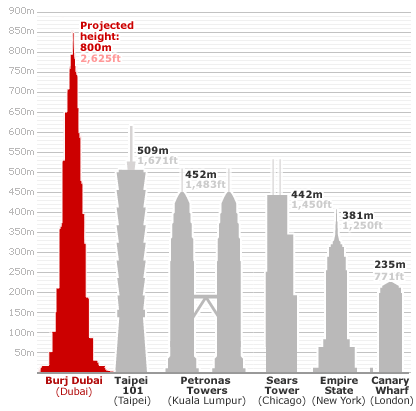
Burj Dubai currently under construction will be the tallest building and the tallest man-made structure in the world. In fact as at of 21 July 2007, the tower's developers reported Burj Dubai's height as 512.1m with 141 completed floors surpassing Taipei 101 (509.2m) as the tallest high rise building in the world.
Burj Dubai designed by Skidmore Owings and Merill will comprise of 162 floors and an overall height of aprox 808m.
Google SketchUp is a free modelling tool which has a lot of features such as importing models into Google Earth. A new podcasting website called The Sketchup Show has been created to help people use SketchUp. It includes video podcasts on tips, tricks and tutorials on modelling in SketchUp. A SketchUp blog has also been created which includes tutorials and other useful information.
Photoshop CS3 has a feature which creates panoramic views. The new photomerge feature combines several photographs into one continuous image. It automatically stitches them together to create panoramic views. You can also create interactive panoramic views.
I think this feature is available in CS2 and CS to some extent.
To view a video tutorial on how to use the photomerge feature on CS3 click here.
MyVu Corporation a company, has developed a product to view ipod videos through a new dimension. It has developed glasses which project videos which can be viewed via a virtual big screen. An amazing technology however, it has some issues which needs to be developed further. It can be purchased via the product website.
For further info visit the blog post on EcoGeek which shows the sustainability of the design and its 'green' features.
EcoGeek has announced the top ten green skyscrapers. To check out the top ten green skyscrapers visit Eco-Towers blog post. Mixed Greens, is an organisation which is working on sustainable and energy efficiency design in skyscrapers.
REALVIZ HDR Imaging Studio is a new product by REALVIZ which combines Stitcher 5.6, VTour 1.2 HDR and Photomatix Pro in order to create HDR environments for virtual reality, architecture, industrial design, special effects and video game applications. With Stitcher 5.6, users can produce HDR panoramas and directly export them as environment maps in a 3D modeling software such as 3ds Max. VTour 1.2 HDR creates 3D virtual tours from existing single environmets or panoramas. It adds HDR depth to environment maps for Spatial Image-Based Ligthing (SIBL). Photomatix pro has tone mapping capabilities and creating HDR images from various exposures.
HyperShot is the world’s first interactive photography software by Bunkspeed. It lets you load 3d models and environments, then lets you see automation in real time. It also delivers real time rendering. "See instant global illumination and physics-based materials on models come alive, right before your eyes…with stunning photographic results." It's another type of rendering software but has other features such as real time interactive view with environmnents and change of renderings of the same object in the same environment.
Squint/Opera is a company which makes films,animations and renders for architectural firms. I came across a few animations which were very interesting and very cool! Below is a presentation created by Squint/Opera. To view more films visit there YouTube site.
To be constructed in Dubai, is this skyscraper designed by architect David Fisher which rotates by wind power. The building rotates by individual floor, creating ‘dynamic architecture’.
Wind turbines are positioned horizontally between each floors which, will produce energy to the building itself and will supply energy for several other buildings. The skyscraper consists of 59 floors and will have 48 wind turbines, making the building to be a Power Station producing Green Energy for the city. In addition to the horizontal turbines, the building is to be fitted with photovoltaic panels on the roof in order to generate more electricity.
Microsoft has launched a new mashup application called Popfly designed for people who do not know how to develope codes.
The free online srvice which is still at its Alpha stage provides a way to construct mashups by combining various web 2.0 applications. The application users microsoft's Silverlight browser plugin which is now in beta. In order to use Popfly Alpha, you have to sent an invitation request. For more info visit webware blog post on popfly.
Below are videos showing what popfly is,its features and how to use the application.
An open-source architecture network has been developed by architecture for humanity, a charitable organisation. It is a great idea in order to share and communicate ideas through an open-source network. Below is a video which shows what the network is all about and who is behind it.
Photosynth is a new software still in development by microsoft which takes a large collection of photos of a place or an object through photosharing applications such as flickr, analyzes them for similarities, and then displays the photos in a reconstructed three-dimensional way.
The video below shows a presentation of photosynth at the TED conference 2007 by its developer Blaise Aguera y Arcas.
Below is a videoof photosynth in action
For further information visit anarchitecture blog on photosynth.
The system requirements to run this application is quite demanding. A good graphics card is reccomended and windows vista. To check out the system requirements click here.
High Dynamic Range images are images which capture the whole dynamic range of a scene. It stores a set of exposures in one image creating depth to provide more information on light, shadows and materiality. To create HDR images, you will need to take 3 or more photos of the same scene in different exposure levels. This will capture the whole dynamic range of the scene in order to create the HDR image.
Below is a short video showing how to create an HDR image using photoshop CS3 (If you have CS2 this is basically the same in terms of its functions and settings).
You can also use a software called photomatix to create HDR images. Click here to view tutorial on HDR images using photomatix.
Check out Flickr to view some interesting HDR images created from photomatix and photoshop.
Now you can customize your driving directions on Google Maps by simply dragging & dropping the default directions to your preferred roads or highways, route around traffic, or add multiple stops on your way.
Google Mapplets are a new feature of Google Maps that combines the Google Gadgets API with the Google Maps API to allow embedding mini-applications within the Google Maps website.
Generative Components is a design tool or a system which enables designers to explore different forms without manually building the detail design model for each scenario. Generative Components graphically presents design ideas and abstract relationships between them in order to create organic forms and geometry. It allows architects and designers to explore design concepts in depth and create forms relating to its design intent.
A new window style which is both a window and can change into a balcony. Bloomframe is designed by Dutch architecture firm Hofman Dujardin.
I guess it's a cool idea but still has issues with its materiality i.e the floor being a wall which would have footprints all over it, an issue which needs to be solved or this could be part of a conceptual idea.
A short video presentation by Nokia illustrates how advances in communications technology might conceptually help architects share their ideas together as a team in order to work better.
Slideshow of the tutotial exercise carried out for BBSc 303. The Exercise consists of renderings done for the Villa Savoye, Vontz Center and the Pregassona House: For more information visit my course website.